Itero deformation monitoring
Itero is a system to monitor deformations of constructions automatically. Itero enables the user to measure on a fixed interval or on a certain time. After setup, no interaction with the total station is needed. Thanks to the rapid setup, Itero is also suitable for short-term monitoring. The data processing is done in the cloud. The results are directly visible for all participants. For each prism, the results are displayed in a diagram or in a table. Additional data such as the total station level and the temperature are also displayed.
Advantages
Power supply via mains power, battery or solar panel
A permanent total station set-up requires a permanent power supply. A short-term set-up requires a flexible solution such as a battery. Itero works with both options. Solar panels can be used to recharge the battery wherever there is no mains power available.
Automatic atmospheric corrections
In order to accurately measure a distance, a total station needs a correction for temperature, atmospheric pressure and humidity. This correction is expressed in ppm (parts pro million). Itero automatically configures the right ppm settings, thus eliminating the need for an on-site weather station. The ppm value is stored and always available with the raw data.
Local coordinates or reference system
The fixed points in your project can be brought into an orthogonal coordinate system by using known prism coordinates. The coordinates of all prisms can then be brought into this coordinate system. Alternatively, a local coordinate system can be used. The orientation of this local system can be chosen arbitrarily.
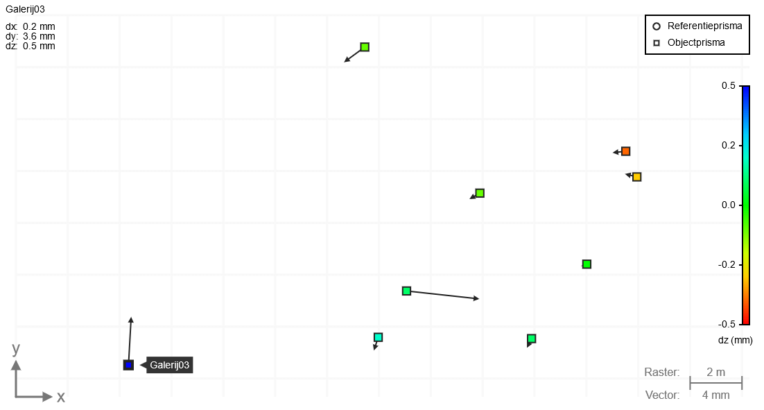
3D-weergave prisma's en vectoren
De weergave kan worden bewogen door te scrollen en te slepen met de muis. Tevens is er een platte 2d-weergave van het boven- of zijaanzicht van de prisma's beschikbaar.
dy:
dz:
dtotal:
Alarm via e-mail or SMS
Measurements exceeding pre-set limit values are reported directly via e-mail or sms.
Support for all Leica total stations and prisms
All Leica total stations are supported by Itero. No software is needed on the device. The system is immediately ready for use. All standard Leica prisms can be used. Other prism types can be defined by the user.
Integration via API and export
The coordinates of the prism positions are immediately available after each epoch. The raw measurement data is accessible as well. The coordinates and raw data are synchronized via API. You can use your own platform to present the data and the results to other parties. The data can also be downloaded as a csv file.
Unlimited projects and prisms
There is no limit to the number of projects that can be created. A project can contain an unlimited number of prisms.
No SIM card or fixed IP needed
Itero is ready to use immediately. There are no additional costs for data transfer. You do not need to supply a SIM card or fixed IP.
No software on total station needed
Itero communicates with the total station by cable. No additional software is needed. Itero restarts the total station automatically in case of a power supply failure.
No software on laptop of pc needed
The configuration of a project and accessing project data is all done on the website. You can simply start a new project on site with your smartphone or tablet. You do not need to install software on your computer.
Demonstration
The video below shows how a deformation monitoring project can be started within minutes. Epochs take place on a given interval. Epochs can also be started manually.